
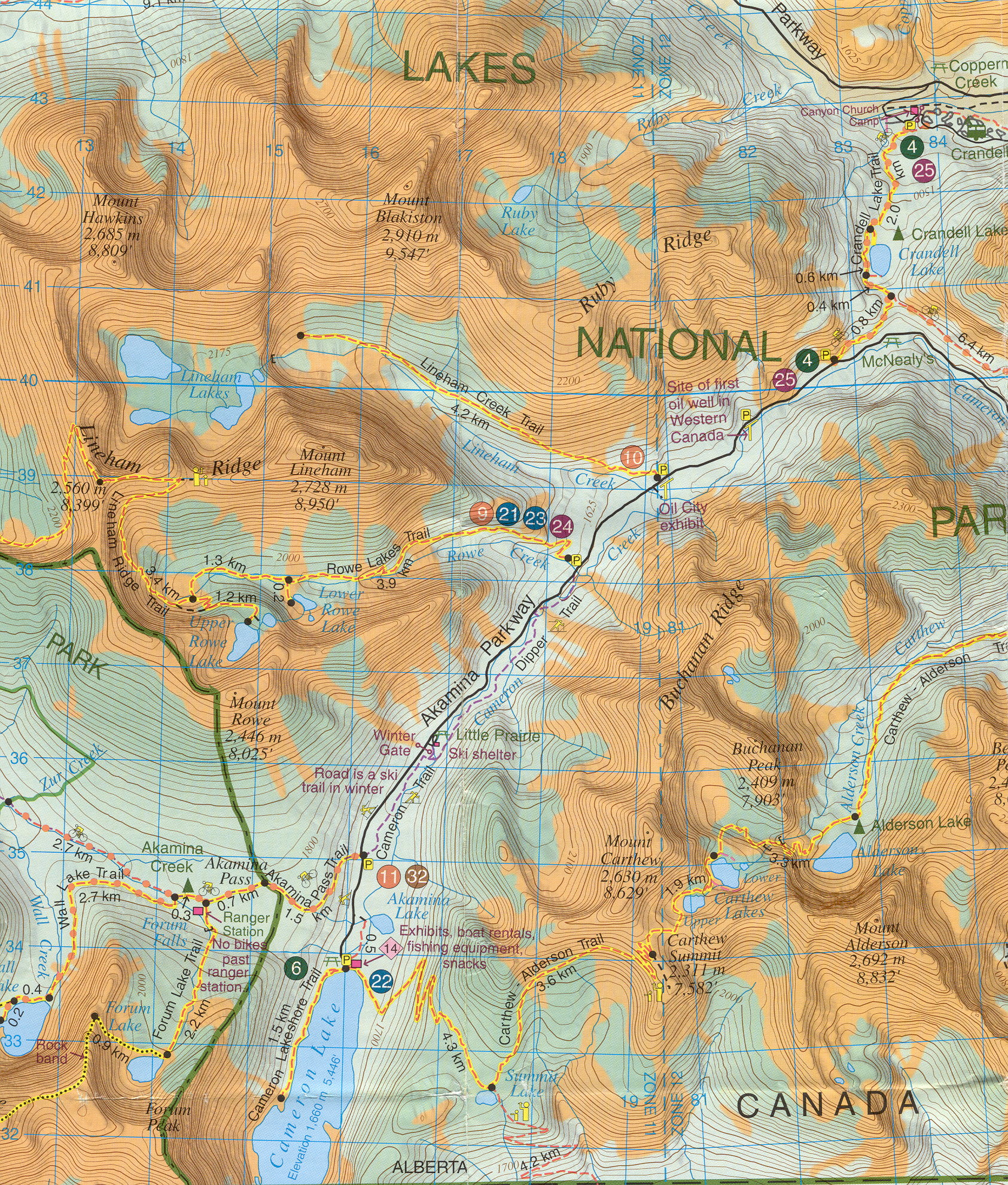
Aug 1 - Aug 3, 2006
Route with Waypoints
| WP Name | Latitude | Longitude | Description | Altitude ft | Altitude m | Gain | Loss |
| LL01 | 49.05811 | -114.0114 | Parking lot | 5331 | 1625 | 0 | |
| LL02 | 49.06216 | -114.02071 | |||||
| LL03 | 49.06096 | -114.0338 | |||||
| LL04 | 49.05763 | -114.04269 | |||||
| LL05 | 49.05772 | -114.05331 | |||||
| LL06 | 49.0591 | -114.06323 | Enter valley | 6562 | 2000 | 1231 | |
| LL07 | 49.05621 | -114.06651 | Start switchback ascent | 6562 | 2000 | ||
| LL08 | 49.06253 | -114.07664 | |||||
| LL09 | 49.06557 | -114.07172 | Follow ridge and cross to other side | ||||
| LL10 | 49.06664 | -114.07943 | |||||
| LL11 | 49.07228 | -114.08547 | |||||
| LL12 | 49.07745 | -114.0858 | Start step initial descent | ||||
| LL13 | 49.07555 | -114.08333 | Switchback descent to lake | 8466 | 2580 | 3135 | 0 |
| LL14 | 49.07398 | -114.08353 | 8313 | 2534 | |||
| LL15 | 49.07181 | -114.0787 | Trail to WP Camp1 or LL23 | ||||
| CAMP1 | 49.07291 | -114.07534 | Lineham Lake 1st night campsite | 7070 | 2155 | 1396 | |
| LL17 | 49.0734 | -114.06959 | |||||
| LL18 | 49.07369 | -114.06024 | |||||
| CAMP2 | 49.07651 | -114.06093 | Lineham Lake 2nd night campsite | 6864 | 2092 | 1602 | |
| LL20 | 49.07795 | -114.0566 | |||||
| LL21 | 49.08091 | -114.05449 | |||||
| LL22 | 49.07893 | -114.05263 | |||||
| LL21 | 49.08091 | -114.05449 | |||||
| LL20 | 49.07795 | -114.0566 | |||||
| CAMP2 | 49.07651 | -114.06093 | Lineham Lake 2nd night campsite | 6864 | 2092.147 | 3135 | |
| LL23 | 49.07432 | -114.07659 | |||||
| LL15 | 49.07181 | -114.0787 | Trail to WP Camp1 or LL23 | ||||
| LL14 | 49.07398 | -114.08353 | 8313 | 2533.802 | |||
| LL13 | 49.07555 | -114.08333 | Switchback ascent to top ridge | 8466 | 2580.437 | 4737 | 1602 |
| LL12 | 49.07745 | -114.0858 | Scramble to top ridge | ||||
| LL11 | 49.07228 | -114.08547 | |||||
| LL10 | 49.06664 | -114.07943 | |||||
| LL09 | 49.06557 | -114.07172 | Follow ridge and cross to other side | ||||
| LL08 | 49.06253 | -114.07664 | |||||
| LL07 | 49.05621 | -114.06651 | Start switchback descent | 6562 | 2000.098 | ||
| LL06 | 49.0591 | -114.06323 | Leave valley | 6562 | 2000.098 | 3506 | |
| LL05 | 49.05772 | -114.05331 | |||||
| LL04 | 49.05763 | -114.04269 | |||||
| LL03 | 49.06096 | -114.0338 | |||||
| LL02 | 49.06216 | -114.02071 | |||||
| LL01 | 49.05811 | -114.0114 | Parking lot | 5331 | 1624.889 | 4737 |
Full map of Waterton Area - 5mb